|

|
"Don't
just dream about a holiday sleeping on deck, under a velvet, star filled sky, listening to the sea lap at the hull
below you
...we can make it a reality for you."
|
|
All Our Cabin Charter Itineraries
|
|
What to bring
Travel
light is our best advice to you, swimwear and T-shirts is all you will need on board in the daytime. In the evenings
people dress casually, but bring sweaters and trousers if you are coming in the cooler months. It's a good idea
to bring a pair of soft shoes or sandals just to use on the boat.
On board we provide hand towels only so please bring your own bath and beach towels. All this should be packed
into a soft bag which can be folded and stowed away to give more room in your cabin, not a suitcase.
The Mediterranean sun is very bright and on a boat hotter than you think, be sure to pack sunglasses, a good suntan
lotion and a hat. If mosquitoes find you tasty then bring mosquito repellent and a camera is an absolute must.
|


|
Today's Weather
|
|
|
Bodrum
|
Marmaris
|
|

|

|
|
Göcek
|
Antalya
|
|

|
|
|
|
|
|
|
 Nereiden
Mon. Nereiden
Mon.
|
|
|
|
|
|
|
|
|
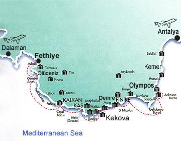
Lycian coast, Fethiye to Antalya
|
 History of Lycia History of Lycia
Map of Lycia
Lycian tombs
Fethiye and Ölü
Deniz
Xanthos and Letoon
Kalkan and Kas
Simena/Kekova/Aperlai
Myra and Saint Nicholas
Patara
Olympos
Phaselis
History. The area known in antiquity
as Lycia occupies a part of South-West Turkey and is one of the richest areas of Anatolia, in both cultural remains
and natural attractions. For this reasons it has become a very popular destination for tourists, who are dazzled
by the wealth and beauty of the land that was once the home of the Lycians.
The name "Lycia" in fact means "country of light", and this characteristic of the land is as
pervasive today as it was in antiquity, proving the accuracy of the ancient derivation of the name. The Lycians,
or Lukka, as they were mentioned in the 2nd millennium texts, were the bravest of the Trojan allies in the Iliad
Herodotus tells us that the Lycians called themselves the Trmmili and claimed to come from Crete. The Lycian language
derives from ancient Luwian,
suggesting that the people either were natives or had been settled in Anatolia for a long time. The land itself
has certainly been inhabited without interruption from prehistoric times. The earliest site in Lycia is on the
coast near Tlos at Girmeler Cave, which dates back to 5,000 BC.
How to discover Lycia. Embarking on one of our gulets in Göcek or Fethiye, you will cruise along the turquoise waters
of the Lycian coastline, one of the oldest sailing routes. We will anchor overnight in the gorgeous coves or bays
that gave shelter to the sea-peoples of the second millennium B.C. and were ports to Greek and Roman navy and merchant
ships. The small ancient harbor sites of Lycia, which will be visited during daily excursions, will give you a
full impression of this unique land and its people.
The whole Lycian coast abounds with massive mountain ranges,
above 3 km in the Akdag and Bey Dag peaks. Most of its wild and sequestered atmosphere can be explained by this
rough orographic terrain.
Not long ago the only practical means of transport was by sea: It took till the 1970's before a proper coast road
- cut through the mountains - finally replaced the unpaved paths.
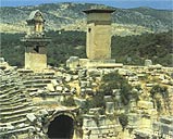
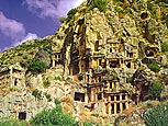
Lycian tombs
Five distinct types of tomb can be distinguished:
Pillar-tombs are specific to Lycia and were for important dynasts.
Temple-tombs are maybe the most impressive of the Lycian tombs and consist of a temple facade with a grave chamber
behind it.
House-tombs were modelled on the wooden houses of the Lycians and so give us some idea of what everyday accommodation
was like several thousand years ago.
Pigeon-hole tombs were the down-market version of temple and house tombs, small unadorned chambers cut into a cliff-face.
Sarcophagi are ubiquitous: even submerged where land retreated. In Roman times the sarcophagi became smaller
and less ornate, perhaps as the importance of ancestor-worship declined.
From Gocek, the bay of Fethiye with its many beautiful anchorages is ideal for those wanting a gentle
start to their holiday. Going East from Karacaoren or Gemiler Bay lies Kalkan and Kas. Sailing on to Kekova Islands,
where you can climb up to Crusader Castle in Kale and look out over fertile valleys and breathtaking sarcophagae.
You can swim over the underwater city and make a river approach to Myra and learn of the origin of St Nicholas.
The Gulf of Gocek, with the friendly Club Marina set in a beautiful pine forest, is one of the Mediterranean's
best sailing spots. Dotted with islands and indented with many coves, its land and seascapes are irresistible.
The ruins of Arymaxa, an ancient city at the southern tip of the gulf, lie at the edge of the azure waters. Opposite
on Tersane Island, stand Byzantine ruins,
Sailing Kalkan, Kas, Finike and Antalya
These eastern Lycian coasts are as beautiful as they are rugged, harbouring an abundance of cultural sites, notably:
Fethiye, Kalkan, Kas, Finike and Antalya. The remains of several ancient cities like Aperlae, Myra, Kale, Olympos
and Phaselis can easily be visited by yacht.
Between Kas and Antalya, the meltemi wind - even in high season - can let you down for days or weeks, and often
sailing yachts will be seen motoring to the next anchorage or port. In these poor conditions, visibility is usually
low and the air moist. Yet, even in these tranquil conditions you will have to anchor safely to allow for the evening
land breeze.
The area is famed for its blue translucent seas and certainly less crowded than the Marmaris and Fetiye area.
 back to top back to top
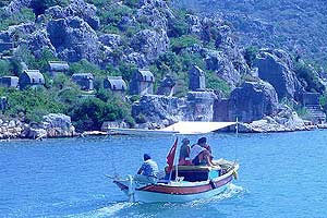
SIMENA (Kale) KEKOVA
The excellent, well-protected anchorage of Kekova is one of the highlights of a Blue Voyage. Submerged ancient
ruins are clearly visible to the naked eye but snorkeling above them is even more thrilling. The village of Kale
has been identified as the Lycian town of Simena where there is still a settlement with stone cottages mixed in
with Lycian and Roman remains. Kekova is a name
|
|
|
|
Kaleköy-Simena
|
|
given to the most scenic area in Lycia along the Turquoise Coast. It covers a large area consisting of Kekova Island,
Kale (Turkish for Castle) village and Ucagiz village. A sunken city was formed by the submergence of ancient cities
probably due to earthquakes.
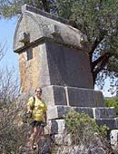
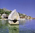
A Lycian sarcophagus standing in the shallows of the harbor of Simena is the most notable ruin. Other remains in
the village are a 1C AD Roman baths complex, a medieval castle with its walls still standing to their full height,
a small theater carved out of rock for approximately 300 people, cisterns and a necropolis with sarcophagi and
rock-cut tombs out of the walls of the castle.
History
From inscriptions that have been found, we know that the history of the ancient city of Simena goes back to the
4th century B.C. If we go ashore and climb the hill behind the houses, we reach the castle of Simena. In the medieval
walls of the inner keep are a few blocks of all that remains of ancient temple. Inside the castle is a small natural
theater carved into the rock. This is the smallest of theaters among the cities of Lycia. West of the theater there
are rock tombs here and there.
Looking from the castle towards Üçagiz it becomes clear how beautiful and safe a natural harbor this
really is. Simena (or Kaleköy, its present-day name) is only a temporary shelter however. The ruins of the
ancient city of Teimiussa are located here. Very little is known about the history of the city however. One inscription
indicates that its history
|
|
|
|
Aperlai
|
|
goes back to the 4th century B.C. The oldest sarcophagus is from the 4th century B.C. and is shaped like a house.
Over it is the nude portrait of a young man. The inscription tells us that it belongs to "Kluwanimiye".
As you pass the little Greek island of Meis on your right your boat may take you into the bay that housed the harbor
of Aperlae, founded by the Lycians and never a very important city. There's not a lot to see here but its
fun to pass over the sunken remains of the harbour buildings.
back to top
-----------------------------
|
|
|
|
Letoon
|
|
Xanthos was the greatest city of ancient Lycia and suffered the gruesome fate of being destroyed several
times by its inhabitants to save it from falling to attacking forces. It was less well defended against the historic
looting during the 1800s, when numerous articles were shipped to the British Museum - their ownership is still
under dispute. Nevertheless, the impressive ruins are still well worth a look.
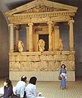
The bilingual inscription known as the "Xanthos Obelisk" and the "Letoon Trilingual", were
instrumental in beginning to decipher the unsolved puzzle of the Lycian language.
The "Xanthos Obelisk" is not actually an obelisk at all but a pillar tomb that has
suffered a lot of damage. An inscription coveres all four side of the stone and is the longerst Lycian inscription
known. Linguistically it falls into three parts: beginning on the south side it continues onto the east side and
part of the north side in the normal Lycian language. It then follows with a twelve-lined poem in Greek, but the
rest of the north side and the whole of the west side is filled with a strange form of Lycian, perhaps ceremonial,
which appears elsewhere only on a tomb in Antiphellos. This inscription is believed to be a narrative account of
the dead hero's exploits.
Xanthos was the greatest city of ancient Lycia and suffered the gruesome fate of being destroyed several
times by its inhabitants to save it from falling to attacking forces. It was less well defended against the historic
looting during the 1800s, when numerous articles were shipped to the British Museum - their ownership is still
under dispute. Nevertheless, the impressive ruins are still well worth a look.
Olympos, Chimaera and Phaselis
Olympos
Though a very ancient city nearby Antalya, in the Mediterranean coast of Anatolia, the early history of Olympus
is shrouded in mystery. We know it was an important Lycian city by the 2nd century B.C., and that the Olympians
worshipped Hephaestos (Vulcan), the god of fire. No doubt this veneration sprang from reverence for the mysterious
Chimeira, an eternal flame which still springs from the earth not far from the city. The town declined in the 1st
century B.C. until the arrival of the Romans in the 2nd century A.D. In the 3rd century pirate attacks brought
impoverishment. In the Middle Ages, Venetians, Genoese and Rhodians built fortresses along the coast, but, by the
15th century Olympus had been abandoned.
Today the site is fascinating, not just for its ruins that are fragmentary and widely scattered amidst the thick
greenery of wild grapevines, flowering oleander, bay trees, wild figs and pines, but for its site, just inland
from a beautiful beach along the course of a stream which runs through a rocky gorge.
Chimeira
The Chimarea take its name from the myth of Bellerophon. The Lycian King, Lobates, sent Bellerophon to kill the
fire-breathing monster, part lion, goat and serpent. With the aid of the winged horse Pegasus, he succeeded, and
returned, after completing other tasks set by Lobates, to Xanthus where he married the king's daughter and became
heir of the Lycian throne. Carried away by his success, Bellerophon tried to ride Pegasus up to Mount Olympus;
for his presumption, he earned a great thunderbolt from Zeus.
Phaselis
Although the Beldibi cave in the vicinity shows signs of pre-historic dwelling, we can trace the city of Phaselis
no further back than the 7th century B.C. The city was colonized by Greeks from Rhodes, possessed three natural
harbors, and was close to a richly forested region. However, as in other areas of the coast of Anatolia, there
were settlements before the arrival of the Rhodeian colonists, and therefore it was probably founded first by force,
or perhaps by gradual integration with the local peoples, after their initial acceptance of the colonists.
Phaselis fell into Persians hands after they took Anatolia, and later on to the hands of Alexander the Great
after he defeated the Persians. Phaselis opened its doors to Alexander, admitting him as a guest. It was here that
Alexander accepted many of the envoys from the cities of Pamphylia, then taking each of the coastal cities in turn,
advanced to Gordion.
After the death of Alexander, the city remained in Egyptian hands from 209 B.C. to 197 B.C., under the dynasty
of Ptolomaios, and with the conclusion of the Apamea treaty, was handed over to the Kingdom of Rhodes, together
with the other cities of Lycia. From 190 B.C. to 160 B.C. it remained under Rhodeian hegemony, but after 160 B.C.
it was absorbed into the Lycian confederacy under Roman rule. Phaselis, like Olympus, was under constant threat
of pirates in the 1st century B.C., and the city was even taken over by the pirate Zekenites for a period until
his defeat by the Romans. In 42 B.C. Brutus had the city linked to Rome. During the Byzantine period, the city
became a bishopric, although in the 3rd century A.D., its convenient harbor had fallen under the threat of pirates
once again. So it began to lose importance, suffering further losses at the hands of Arab ships, until totally
impoverished in the 11th century A.D. When the Seljuks began to concentrate on Alanya and Antalya as ports, Phaselis
ceased to be a port of any note.
Although the ruins are not extremely exciting, the setting is one of the more beautiful, incomparably romantic
ones that can found on this part of the Mediterranean coast.
Phaselis is a city of natural harbors of which she had at least three. Near the car park is the northern
PHASELIS is an ancient city where only surface excavation has taken place. This is why it is still among
pine trees and under green vegetation. The combination of ancient remains with a forest surrounded by sea on three
sides makes it a beautiful national park.
History of Phaselis Located between the borders of Lycia and Pamphylia, Phaselis was
legendarily founded by colonists from Rhodes in 690 BC. Because the land was not suitable for agriculture, Phaselitans
excelled as great traders. They are supposed to have bought the land in exchange for dried fish which led the emergence
of a proverb "Phaselitan sacrifice" to be used for cheap offerings.
 Phaselis was overrun by
the Persians in the 6C BC and freed in the 5C BC. They minted coins in the 5C BC which show the bow of a ship on
one side and the stern on the other. Phaselis proved its independence from Lycia by siding with Mausolus, the satrap
of Caria, in the 4C BC. When Alexander the Great came in 333 BC they offered him a golden crown. This attitude
showed Phaselitans reaction to authority. Phaselis was known as the most prominent port city to the west of the
Gulf of Antalya, until the city of Attaleia was founded. Phaselis was overrun by
the Persians in the 6C BC and freed in the 5C BC. They minted coins in the 5C BC which show the bow of a ship on
one side and the stern on the other. Phaselis proved its independence from Lycia by siding with Mausolus, the satrap
of Caria, in the 4C BC. When Alexander the Great came in 333 BC they offered him a golden crown. This attitude
showed Phaselitans reaction to authority. Phaselis was known as the most prominent port city to the west of the
Gulf of Antalya, until the city of Attaleia was founded.
The Site Three harbors of Phaselis, north, city and south, are arranged around a 400-meter-long (1,310 ft)
peninsula. These harbors served the citys trade activities, particularly the export of local timber, rose and
lily oil. Between the middle harbor and the monumental gate near the south harbor is the Main Street. On both sides
of the 22-meter-wide (72 ft) main street are important Roman and Byzantine public buildings, baths complex, agora
and suchlike. The Monumental Gate, built of gray-white marble blocks, was erected in the 2C AD in honor of Hadrians
visit. The Roman Theater which probably had replaced an earlier Hellenistic theater, lies to the east of the main
street on the hillside of the Acropolis.harbor, next to this the naval base, and to the south the southern harbor,
popular today with swimmers and yachts. The two small islets on the northern harbor were joined to the mainland
by a pier which extended from the walls around the promontory. It is still possible to see the remains of this
pier and the walls.
In this once favored port of ancient times, the visitor can find many ancient ruins. The remains of the aqueduct
are partially standing; beyond these one can see the naval harbor road, which is linked to the northern harbor.
On the road facing the southern harbor is a portal leading to the harbor, built during the reign of Hadrian. On
the sides of the roads are to be found the remains of a large number of shops. Across the tree-covered site to
the south of this road can be seen the commercial agora, the Domitian Agora and the later agora. Returning along
the same route you pass through the Gate of Hadrian along the main road and come to the theatre. The Acropolis
was surrounded with walls and the theater was founded on the north-western slopes. The auditorium and skene are
still identifiable, and date from Roman period.
After looking at the theater, you may continue to the harbor area and visit the inner harbor. The necropolis was
situated stretching beyond the aqueduct over the steep slopes behind the harbor. There are still many graves to
be seen there.
The three harbors are perfect for swimming since part of the ruins are now submerged, making swimming and snorkeling
very entertaining and exciting.
back to top
Located about 1 mile outside Demre, the ruins of Myra include
an amazing collection of tombs cut out of the cliffs above the city, all in the form of temple facades, arranged
in an asymmetric jumble. Most of them are 4th century BC, and many contain funeral scenes in relief. One of these
preserve a painted frieze showing the indoor and outdoor life of the man and his family with servants in attendance
and it is one of the most remarkable rock-tombs in Lycia.
Although the date of the foundation is unknown there are some Lycian inscriptions found in the area that indicate
that the settlement existed since the 5th century B.C.. Strabo counts it among the six notable cities of Lycia.
It still remained important during Roman times and after.
The huge late-Roman theater is one of the main attractions of Myra. It still preserves its double-vaulted corridors
and an inscription in a stall space that reads "place of the vendor Gelasius," where Gelasius would have
sold whatever the show viewers munched on as they watched the representation.
In the 2nd century A.D. it became a diocese, and it was during that period that its theater was built. During the
Byzantine period, Myra maintained its role as a religious center.
I
back to top
---------------------------------------------------------
MYRA
The ancient city of Myra, located a few kilometers out of Demre, was one of the earliest Lycian cities. Demre is
the modern-day site of the city of Myra, where
|
|
|
|
Letoon
|
|
St Nicholas (Santa Claus) was bishop in the 4th century, and the ruins of which include a theatre dating from the
2nd century BC. Demre continues to be overlooked by a spooky looking cliff face carved with many Lycian rock tombs.
History of Myra Although according to ancient sources the name of Myra only goes back as early as 1C BC, the inscriptions
or coins found imply that it must have been from the 5C BC. Myra was always one of the most important cities in
Lycia, and during the Hellenistic period was one of the six cities in the Lycian League that had the maximum quota
of three votes at meetings of the federation.
In the Byzantine period Myra was a prominent city and during the reign of Theodosius II Myra became the capital
of Lycia. However, in the Turkish period it was abandoned.
The Site The ruins consist mainly of a theater and some of the best examples of L
|
|
|
|
Myra -
Rock tombs
|
|
ycian rock-cut tombs. The rest of the city has not been excavated yet. The acropolis, as expected, is at the top
of the hill. In early Christianity, 60 AD., St. Paul met with his followers here on his way to Rome.
The Roman Theater is well preserved. In the center of the two-meter-high wall (6.5 ft) backing the diazoma, near
the stairs leading to the upper rows is a figure of Tyche, the Goddess of fortune, with an inscription "Victory
and good fortune to the city beneath". The stage building, like in all Roman theaters, is very ornate.
The 4C BC Rock-cut Tombs, some with temple facades and beautifully carved reliefs representing the dead and their
families or warriors, are among the most fascinating remains of Anatolia. Inscriptions are usually in Lycian.
Saint Nicholas was born in Patara and became the bishop of the Christian
church of Myra, in Lycia, about whom little is known with certainty. His fame as a gift bringer derives from the
time when he heard of a bankrupt merchant who could find no dowry for his three daughters. Unseen, he thew three
bags of gold into the merchant's house down the chimney and by luck they fell into the girls stockings that were
drying by the fire. From this grew the legend of secret present giving. The story provides the foundation for the
custom, still practiced in many countries, of giving gifts in celebration of the saints day, which was December
6. Saint Nicholas is the patron saint of children and sailors. Variations of his name range from Sant Nikolaas
to Sinter Klaas to Santa Claus; he is known as Father Christmas in England, Grandfather Frost in Russia, Pere Noel
in France and Saint Nick in the United States.
St. Nicholas was buried in a tomb outside the city of Myra although his bones were stolen in A.D. 1087 by sailors
from Bari, Italy. However, the Venetians also claim to have the bones of the saint, as do the Russians and the
Antalya museum.
back to top
back to top
|
|
|
|
Patara
|
|
Patara is one of the most beautiful, and longest, beaches in the Eastern Mediterranean, with 18km of deserted
white sands. Nearby are the ruins of the Lycian city of the same name - a major harbour and trade centre and the
sanctuary of the God Appollo. Patara is renowned as the birthplace of St Nicholas, the bishop of Myra, now known
and loved in the west as Santa Claus.
Statue of Saint Nicholas, The Church of St. Nicholas, Demre
back to top
.
Kas, Kalkan and Aperlai
Kas was originally called Habesos or Habesa in the ancient tongue of Lycia and later was given the name Antiphellos.
Kas was founded on the ancient town of Antiphellos and the Lycian style sarcophagus at the beginning of the avenue
running down to the port is almost the symbol of this lovely town near Antalya in the Mediterranean region south
of Turkey.
Antiphellos, which once was a member of the Lycian League, is known to have gained reputation and importance
as a port town during the Hellenistic period, sustaining its significance as one of the leading towns during the
Roman period as well.
Today's Kas is a coastal town of the Lycians. "Phellos" is the Greek word for "stony place"
and this name is very well suited to Kas. Its well preserved rock tombs and theater are well worth seeing.
Kas today is a small and charming coastal resort where many sailing boats anchor in its small marina.
Kalkan
Kalkan is a lovely small hilltop town that overlooks a tiny bay. Its quaint, traditional, white-washed houses,
shuttered windows and balconies garlanded with brilliant flowers that cascade to the streets below, make it the
ultimate in a peaceful holiday town in the Mediterranean region of Turkey. Narrow winding streets lined with souvenir
shops lead down to the charming marina.
Every morning boats busily take tourists to one of the nearby beaches or small bays. As the sun sets it is Kalkan
style to meet on the roof terraces for a drink before dinner and enjoy the comings and goings of the yachts, the
business of the marina and the panoramic view.
Kalkan is situated on a beautiful small bay near Antalya province. Nearest airport is Dalaman (2 hours by taxi).
You can enjoy a daily island excursion in a gullet (wooden hulled local boats), a moonlight dinner cruise, or go
by minivan to the nearby villages of Patara and Bergin. Patara beach is a 20 km long, unspoiled white sand beach
12 km from Kalkan. There is another beautiful small sandy beach (Kaputas beach) 5 km from Kalkan. Unfortunately
there are no sandy beaches in Kalkan.
Aperlai
Aperlai is located on the Sicak peninsula, near the Sicak jetty. A Lycian city, Aperlais history is known from
coins bearing its name that have been discovered and goes back to the 4th or 5th centuries B.C. Aperlai was the
head of the Lycian Confederacy, of which Simena and Apollonia were also members.
The city walls begin at the seashore and are fortified with towers at intervals. These walls, with their rectangular
and polygonal construction, are from Roman times. Other remains at Aperlai are all from the Byzantine and later
periods. The western reaches of the wall are of rectangular construction. There are three gates in this wall, two
of which have a plain and the third a blind archway. The southern reaches of the walls are of polygonal construction
and in a bad state of repair. This side is reinforced with two towers and it is here that the main gate was located.
Outside the walls are typical Lycian sarcophagi from Roman times.
Kekova, "home of the sun," is an island an hour from Dalyanagzi (ancient Andriace) by sea, as
well as the name of a whole ensemble of picturesque islands with numerous bays and ancient cities. These bays provide
natural harbors in all seasons, and yachtsmen particularly enjoy exploring the unspoiled landscapes. Along the
northern shore of Kekova Island, at Apollonia, earthquakes once disturbed the land causing some of the ancient
houses to sink under the clear water, creating a sunken city. Kalekoy Castle (ancient Simena) offers a bird's-eye
view of the bays, inlets, islands and colorful yachts sailing peacefully on the glassy water. Kekova has the blue
skies and orange sunsets of a Van Gogh painting, along with starry nights, peace and tranquillity, playful dolphins,
mythological mysteries, and the sparkling sea - all this and more. At Demre (Kale), the ancient Myra, (25 km west
of Finike), many splendid carved-rock tombs overlook the magnificent
St. Nicholas Church - Demre, Antalya
Roman theater. St. Nicholas was the bishop of this Mediterranean city during the fourth century and died here in
342. Finike is an official entry-port and is surrounded by citrus trees and gardens. Thirty-two kilometers from
the Finike Marina are the remains of the beautiful and ancient Lycian city of Arikanda. A mountain trek inland
rewards you with superb views, fabulous ruins and fresh mountain air.
Slipping around the Kirlangig Peninsula brings you into the Gulf of Antalya. The first sight you come to is the
ancient city of Olympos, on the southern side of Mt. Tahtali (Mt. Olympos). Oleander and laurel bushes shade the
Olympos Valley, which you can approach by land as well as by sea. Nearby at Yanartas. (at a height of 300 meters),
the mythological Lycian hero Bellerophon mounted his winged horse Pegasus and slew the fire-breathing Chimaera.
Gas seeping from the earth and burning brightly at night give the place an
Itinerary: Fethiye
Olu Deniz Gokkaya Simena Ucagiz Myra Olympos Fethiye  ... more
Olympos was an important Lycian city built on the banks of the river. Its inhabitants worshipped the god
of fire - on the side of Mount Olympos are springs of continually burning methane gas
|
|
|
|
Letoon
|
|
Xanthos was the greatest city of ancient Lycia and suffered the gruesome fate of being destroyed several
times by its inhabitants to save it from falling to attacking forces. It was less well defended against the historic
looting during the 1800s, when numerous articles were shipped to the British Museum - their ownership is still
under dispute. Nevertheless, the impressive ruins are still well worth a look.
Xanthos was the capital city of the Lycian Federation and its greatest city for most of Lycian history. It was
made famous to the Western world in the 19th century by its British discoverer Charles Fellows. Xanthos is of great
antiquity - finds date back to the 8th century B.C. but it is possible that the site may have existed during the
Bronze Age or during the Iron Age.
Xanthos stands up atop an elevated area within Xanthos Valley with the Xanthos River flowing closely under the
city's west side.
From this elevation one receives a supreme view of the valley surrounded by the spectacular Taurus mountains.
The ancient Lycian site of Xanthos lies a few kilometres south of Letoon, close to the village of Kinik. On the
road from Fethiye to Kalkan there is a sign post - a track leads off left up to the ruins.
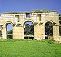
LETOON
Letoon was the sacred cult center of Lycia and its most important sanctuary dedicated to the three national deities
of Lycia - Leto and her twin children , Apollo and Artemis. Letoon was a shrine and not actually a city, though
it did have a settlement surrounding it.
This was the spiritual heart of Lycia, its federal sanctuary and the place of national festivals. The features
of Letoon include the remains of three temples, dedicated to one of Leto and her twins Artemis and Apollo, an agora,
a nymphaeum and an amphitheatre.
Kalkan is a quiet port town built on the steep hillside leading down to the harbour. Its very pretty,
with charming, winding streets lined with old buildings, quaint shops and streetside quiet restaurants and bars.
From Kalkan, its not far to Patara, Xanthos and Letoon, another Lycian settlement, which was named after the goddess
Leto, mother of Apollo and Artemis.
Kas is just around the coast from Kalkan. Its slightly larger and more developed than its neighbour
but still very charming, with streets and shops leading down to the sea. Kas was one of the earliest settlements
of the Lycian era, when it was called Antiphellos. A large sarcophagus dominates the centre of town, and the sheer
rock face overlooking Kas is dotted with Lycian rock tombs. The Greek Island of Meis lies just off the coast.
sunken city picture Andrys Basten http://www.pbase.com/andrys/
--------------------------------------------------------
|
|
|
|
Myra - Rock tombs
|
|
---------------------------------------------------------------
Kekova Island and the town of Kale nearby Antalya make an idyllic daytrip for the traveler looking for
a combination of sunshine, swimming and fascinating historic ruins. Many operators run trips from Kas but the journey
is much shorter from Çayagzi, the harbor of Demre. Along the stony coastline the boatman may stop at a cave,
or point out the occasional goat or the smoldering pyramids of wood used by peasants to make charcoal, the product
may sit in plastic sacks at the water's edge, waiting to be taken away.
Kekova
Kekova Island and the town of Kale nearby Antalya make an idyllic daytrip for the traveler looking for a combination
of sunshine, swimming and fascinating historic ruins. Many operators run trips from Kas but the journey is much
shorter from ?yagzi, the harbor of Demre. Along the stony coastline the boatman may stop at a cave, or point out
the occasional goat or the smoldering pyramids of wood used by peasants to make charcoal, the product may sit in
plastic sacks at the water's edge, waiting to be taken away.
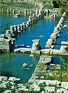
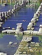
Along the edge of the island facing the mainland lie the fascinating half-submerged remains of a Lycian sunken
city, and probably from Byzantine times later on. Signs warn against skin- diving, so you can not swim here because
many foreigners in the past took a piece of ancient relics with them as a souvenir. The boatman will allow the
passengers on board off for a swim further to the west, where the remains of a Byzantine chapel stand on the beach
and where further sunken remains can be explored at ease by the swimmer with mask and snorkel.
A fascinating Lycian necropolis, with chest-type tombs spread out along the coastline, lies at Teimiussa, near
the present-day ?agiz on the mainland across from Kekova. This can also be reached by track from the main road
between Kas and Demre, where it is signposted. The boat-tripper may be content with a sea-born view and pass to
Kale, the ancient Simena, which sits nearby below the crenellated ramparts of an earlier hilltop Roman castle.
The castle houses a small theater, cut into the rock, for just about 300 people, a sign that this was a minor settlement
in Roman times. Down in the harbor the turquoise sea laps at waterside restaurants offering good Turkish food including
locally caught fish. A lone Lycian sarcophagus standing in a few centimeters of water at the western side lures
visitors to pose beside it for photographs.
Today Kekova is a very popular anchorage for sailors who enjoy the history together with the nature.
Simena (Kale)
From inscriptions that have been found, we know that the history of the ancient city of Simena goes back to the
4th century B.C. If we go ashore via the jetty next to the sarcophagus on the seashore and climb the hill behind
the houses, we reach the castle of Simena. This castle was used during the Middle Ages by the Byzantines. In the
medieval walls of the inner keep are a few blocks of all that remains of ancient temple. Inside the castle is a
small natural theater carved into the rock. This is the smallest of theaters among the cities of Lycia. West of
the theater there are rock tombs here and there. Above the rock tombs is a Roman wall built of dressed stone and
located on the wall are late-period embrasures thus giving one a glimpse of three eras simultaneously. On the shore
are the ruins of public baths whose inscription is still legible and reads "A gift to the emperor Titus made
by the people and council of Aperlai as well as by the other cities of the confederation."
Looking from the castle towards ?agiz it becomes clear how beautiful and safe a natural harbor this really is.
Simena (or Kaleköy, its present-day name) is only a temporary shelter however. The actual shelter for yachts
is Teimiussa (?agiz), a landlocked bay surrounded by green hills. There is a road overland that leads here. The
ruins of the ancient city of Teimiussa are located here. Very little is known about the history of the city however.
One inscription indicates that its history goes back to the 4th century B.C. One sees mostly the ruins of a necropolis
here and no city walls or other major structures have been encountered. The oldest sarcophagus is from the 4th
century B.C. and is shaped like a house. Over it is the nude portrait of a young man. The inscription tells us
that it belongs to "Kluwanimiye". The work is Roman and a later addition to the sarcophagus.
One may reach Kekova overland from Demre ?ayagzi as well as in boats that you can rent at Kas. After leaving Kekova
you pass Kisneli Island and Asirli Island and come to Gökkaya harbor. Gökkaya is a beautiful bay and
a fine harbor. On the way is a big sea cave that was used at one time by pirates. From here one comes to ?yagzi
(Demre), also called Kokar bay, alongside of which are the ruins of Andreake. From here, one may take a car to
Myra, the city of St. Nicholas, which is quite close. This is also a place from which one may visit other Lycian
cities as Isinda at Belenli, Apollonia at Kilincli, Istlada at Kapakli, Kyaenai at Yavu, and Trysa and Sura at
Gölbasi. The area is also filled with thousands of Lycian sarcophagi lying everywhere.
back to top
----------------------------------------------
A cruise back into history - eastwards from Kekova, there
are relatively few anchorages but the backdrop of magnificent mountains, the legendary Chimarea, shades of Nelson,
ancient Phaselis and the Fishermans' Harbour in Antalya. A contrast of the old and the new.
Kalkan is a quiet port town built on the steep hillside leading down to the harbour. Its very pretty,
with charming, winding streets lined with old buildings, quaint shops and streetside quiet restaurants and bars.
From Kalkan, its not far to Patara, Xanthos and Letoon, another Lycian settlement, which was named after the goddess
Leto, mother of Apollo and Artemis.
The Gulf of Kekova is one of the most picturesque stretches of the coast and has several bays and villages to explore.
The charming village of Üçaðýz (literally three mouths) has a few remains of the Lycian
village of Teimiussa. On Kekova, there is no trace of the city which once dominated the island - its ruins and
foundations can now only be seen under the surface of the clear water on the northern side of the island. On land,
theres nearby Kale, a village on a steep hillside leading up to the medieval fortress and theatre of ancient Simena.
The local landscape is dotted with the ruins of Lycian tombs, forts and Greek settlements.
Olympos was an important Lycian city built on the banks of the river. Its inhabitants worshipped the god
of fire - on the side of Mount Olimpos are springs of continually burning methane gas.
These are just highlights! Turkeys coastline has many places to explore: youll find it a seductive combination
of rugged mountain scenery with pine forests and azure waters, brilliant blue skies, endless sunshine and awe inspiring
legacies of an ancient past.
back to top
|
|
|
|
Myra - Rock tombs
|
|
One may reach Kekova overland from Demre Çayagzi as well
as in boats that you can rent at Kas. After leaving Kekova you pass Kisneli Island and Asirli Island and come to
Gökkaya harbor. Gökkaya is a beautiful bay and a fine harbor. On the way is a big sea cave that was used
at one time by pirates. From here one comes to Çayagzi (Demre), also called Kokar bay, alongside of which
are the ruins of Andreake. From here, one may take a car to Myra, the city of St. Nicholas,
which is quite close. This is also a place from which one may visit other Lycian cities as Isinda at Belenli, Apollonia
at Kilincli, Istlada at Kapakli, Kyaenai at Yavu, and Trysa and Sura at Gölbasi. The area is also filled with
thousands of Lycian sarcophagi lying everywhere.
Lycia and the Lycians
Ancient Lycia encompasses the sea-girt bulge that runs from Ekincik and ancient Caunos around as far as Antalya,
a semi-circle of some of the most mountainous and wild landscape to be encountered anywhere in Turkey. During the
Ottoman period it was called 'Uc', the 'Frontier', a name that conjures up the nature of the landscape. It is a
region hemmed in by mountains. On the west and east two high mountain ridges, the tallest peaks standing well over
3000 meters (10,000 feet) high, cut off Lycia from neighboring Caria to the west and Pamphylia to the east. In
the north a lower but no less rugged range and a great plateau cut Lycia off from central Anatolia. Around the
coast a series of mountain ranges drop precipitously into the sea and though the peaks are not as high as those
in the interior, the aspect from seaward is of an inhospitable coast. Right into early summer the highest peaks
in Lycia, Akdag in the west and Bey Dagi (ancient Mt Solymnus) in the east, are covered in snow on the highest
slopes.
As the landscape is wild, so were the men who lived here. The Lycians enjoyed a reputation for independence and
fought for it tooth and nail, often to the last man. This last statement is not a clichÈ tacked on for effect,
on at least two occasions we know it to be fact. In 546 BC the Persians defeated Croesus, the last Lydian king,
and advanced upon Lycia. On the Plain of Xanthos the Lycians met the much superior forces of the Persians, to no
avail. Herodotus tells us of the tragic finale to the battle:
"When Harpagus advanced into the plain of Xanthos, they met him in battle, though greatly outnumbered, and
fought with much gallantry; at length, however, they were defeated and forced to retire within their walls, whereupon
they collected their women, children, slaves, and other property and shut them up in the citadel, set fire to it
and burnt it to the ground. Then having sworn to do or die, they marched out to meet the enemy and were killed
to a man."
Five hundred years later in 42 BC it all happened again when Brutus besieged Xanthos. Against a superior force
the Lycians fought to the finish, and when they saw there was no hope of victory, they once again slew their women
and children and burnt the city down. Plutarch recorded Brutus' feelings on this second mass suicide:
"It was so tragically a sight that Brutus could not bear to see it, but wept at the very mention of the scene.
Thus the Xanthians, after a long space of years, repeated by their desperate deed the calamity of their forefathers,
who after the very same manner in the Persian Wars had fired their city and destroyed themselves."
Such was the feeling of the Lycians towards independence that they were the last region to be incorporated into
the Roman provinces in Asia Minor.
Who were these Lycians and where did they come from? They are mentioned in Homer's Iliad where they fought on the
side of the Trojans in defense of Troy, a gallant force from "distant Lycia and the eddying Xanthos".
Herodotus fills us in on the details. The Lycians, he says, came from Crete after "Sarpedon and Minos, fought
for the throne, and the victorious Minos expelled Sarpedon and his party". They were then called the Termilae,
and only adopted the name Lycian when the noble Lycus, son of King Pandion was expelled from Athens and came to
join Sarpedon. From Lycus they adopted the name Lycian. It's all a bit tortuous and not as interesting as the light
Hittite and Egyptian references throw on the origins of the Lycians. The Hittites record that a maritime people
called the Lukka lived here sometime in the 14th century BC. Egyptian records mention a people called the Lukki
living here, a people feared as sea-raiders. This latter reference makes a good deal of sense on later evidence.
The Lycian coast has often been referred to as the 'pirate coast', and with it's many strategically sited coves
and islands where these sea-raiders could lie in wait for plump merchant ships tramping up and down the coast,
it deserves the epithet. Numerous campaigns were mounted to clean up the coast from as early as 1194 BC right up
until the 19th century. A relief at Medinet Habu in the Nile delta records how Ramses III put together a great
fleet to take on the Lukka and decisively defeated them, leaving the coast free of piracy for a while. When Xerxes
assembled his huge force for the invasion of Greece in 480 BC the Lycians contributed fifty ships and Herodotus
gives us this tantalizing description of the piratical bunch that manned them:
"They wore greaves and corsets; they carried bows of cornel wood, cane arrows without feathers, and javelins.
They had goatskin slung round their shoulders, and hats stuck round with feathers. They also carried daggers and
rip-hooks."
Piracy is again mentioned in the 5th century BC, but it is not until the Roman occupation of Asia Minor that attempts
were again made to bring it under control. In 78 BC a campaign was mounted by Servilius Vatia, governor of Cilicia,
and though he had moderate success, it did little to check it. In 67 BC Pompey, an able and intelligent admiral,
was given wide-ranging powers and almost unlimited resources to tackle the piracy problem, which he did with total
success. However Pompey was reluctant to give up his power and his ships and became himself something of a thorn
in the Senate's side. After the fall of Rome the Lycian coast once again became a haven for pirate fleets and not
until the 18th and 19th centuries and the presence of the British Navy was the piracy problem again tackled and
the Lycian coast cleaned up.
In this remote region the sites of over forty cities have been found and much remains to identify the culture of
the Lycians. The most obvious features of the Lycian landscape are the tombs and sarcophagi left behind. They are
everywhere and it is difficult not to think of the region as a vast necropolis peopled with the shadowy figures
of Lycian nobles and warriors. Ancestor-worship was evidently important to the Lycians and the tombs are extravagant
affairs, the more grandiose decorated with a frieze and inscriptions placing a curse upon anyone tampering with
the tomb. Five distinct types of tomb can be distinguished: pillar-tombs, temple-tombs, house-tombs, pigeon-hole
tombs, and the ubiquitous sarcophagi. Pillar-tombs are specific to Lycia and consist of a long tapering pillar
set on a stone base with the grave chamber at the top. These were for important dynasts and the best examples are
at Xanthos. Temple-tombs are maybe the most impressive of the Lycian tombs and consist of a temple facade with
a grave chamber behind it. Those at Caunos are the most romantically sited while those at Fethiye the most accessible.
House-tombs were modeled on the wooden houses of the Lycians and so give us some idea of what everyday accommodation
was like several thousand years ago. They are smaller than the temple-tombs, though often several stories high,
and the stone has been hewn to imitate wooden roof beams and the doorway and portico. The house-tombs were sometimes
decorated with relieves and painted as at Myra where fragments of a painted relief have miraculously survived.
Pigeon-hole tombs were the down-market version of temple and house tombs, small unadorned chambers cut into a cliff-face.
The best examples are at Pinara where the cliffs are literally pock-marked by these tombs. Sarcophagi are found
everywhere: scattered over hill-sides, on the summits of hills, by the shore, and in the sea where the land has
subsided. The older sarcophagi are the largest with massive stone bases, grave chambers, and heavy lids often with
a peaked 'gothic' look to them. In Roman times the sarcophagi became smaller and less ornate, perhaps as the importance
of ancestor-worship declined.
With the decline of the Roman Empire, so too Lycian fortunes declined. In Byzantine times there were small settlements
around the coast, a number of Byzantine churches will be seen in isolated spots, but the interior was not heavily
populated as in Lycian times. In the late Middle Ages this region was viewed as a wilderness, the region of "Uc",
the "Frontier" of the Ottomans, and the coast was the haunt of pirates who had semi-permanent settlements
ashore.
The Lycians and Lycian culture faded into vague folk-memories of a proud and independent people who had built great
stone cities and buried their dead in magnificent tombs. Not until those intrepid travelers of the 19th century,
Francis Beaufort, Charles Newton, Thomas Spratt and Edward Forbes, was the existence and extent of Lycian culture
to be brought to the notice of the west.
Cabin Charter general information
Please note that this is only
a rough guide and can be varied to suite requirements. Also note that the route may vary slightly, depending on
weather conditions and time available, at the Captains discretion.
Home || Blue Cruise || Itineraries || Boat charter || Pictures || How to book
|
|